Explanation
of South Boundary Confusion
In the late 1800s, the Neblett family sold 1000 acres on the west side of the Old Ridge Road (today HWY 138) to Fletcher Manson, a neighbor to the North. Mr. Manson divided and re-sold this tract. My Great-Grandfather, David Overby purchased the Southernmost 200 acres, making annual payments to Mr. Manson. In the early 1900s ca. 1908, there was an opportunity for David Overby to sell the original growth pine timber on his farm to the Emporia Lumber Company. The agent for the Lumber Co. arranged to pay-off the remainder owed to Mr. Manson with a portion of the timber sale proceeds, thereby giving David Overby a clear title deed to the 200 acres. The agent also arranged for a survey of the 200 acres, this survey experience, as related by my Grandfather, James Overby, follows below.
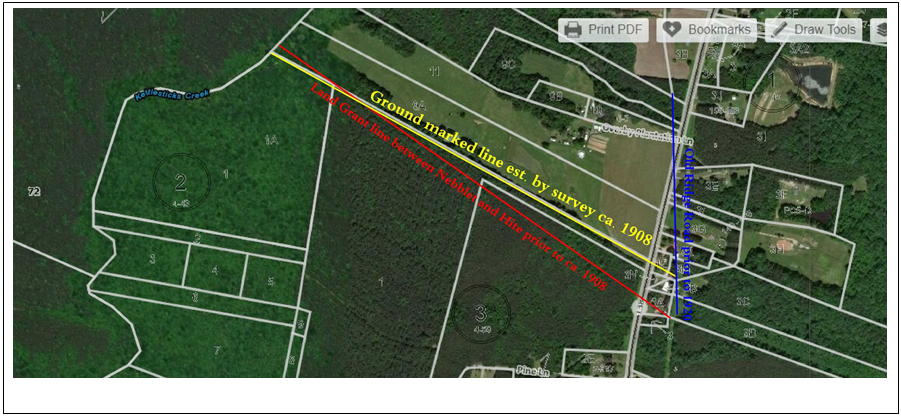
In the early 1900s most of the original growth pine in the surrounding area was sold to the “Emporia Lumber Company”, they laid railroad track throughout the area with the main lines having some rather impressive grades of cut and fill which are still visible today. Laterals into the timberlands were referred to as “Dinky Lines”, these track were more temporary, used to haul the logs out and then moved into new areas. One Dinky Line came across the 200 acre track and lost rail spikes can still be found in the fields. Reportedly the lumber from this timber harvest was carried by rail to Norfolk and loaded onto ships bound for Europe. David Overby sold the timber on the 200 acre tract at that time reserving 2 acres to the West behind his home. My grandfather, James, was in his early teens (ca.1908) and helped the survey crew cut sight lines as they surveyed the 200 acre tract prior to the timber sale. He related a story of this experience as follows, as the crew was establishing the southern boundary of the property, the adjoining landowner was with the crew also. This adjoining landowner was Robert Hite, he was the local magistrate (judge) and the postmaster as the post office was in his home. He prepared deeds for land transfer and notarized the signing of deeds, etc. He also held local court in the yard of his home to settle disputes, etc. As the survey crew was establishing this Southern boundary of the 200 acre tract, with this boundary being a Land Grant line of the Neblett grant, Mr. Hite was concerned as he could see that the straight line from Kettlestick Creek to Stoney Creek was going to pass further South than he had anticipated and actually pass through an open crop field which he had been claiming as his own. My grandfather said that Mr. Hite kept saying “this line is going through my lot”, as the survey crew got closer to his open field (lot) he grew more anxious and eventually called a hushed meeting with the surveyor. After this conference, the crew returned to the starting corner on Kettlestick Creek and actually moved the corner South about 300 feet and then surveyed a new course with a more Northerly trajectory crossing the original line about 1/5 of the way along the line from Kettlestick . This revised angle resulted in the line not passing through Mr. Hite’s open field and the addition of approximately 10 acres to his property. So the Land Grant line (a straight line from Creek to Creek) is now no longer a straight line. To cover this abnormality, the Surveyor, who was Mr. Hite’s Nephew, proceeded to show the compass directions and angles/distances on the survey plat as they would have been with a correct survey of the existing King’s Grant line. He proceeded to continue the survey of the 200 acre tract using the newly established line (the ground marked line) and surveyed the 200 acres to be divided from the Manson tract. In essence the result is that Mr. Manson lost approximately 10 acres as Mr. Hite gained it. This intentional error was covered up as the plats were recorded with the County. There have been several confused surveyors since that time, but the erroneous ground line has prevailed.
Note that in the 1920s the Old Ridge Road (today HWY 138), was moved to its present location.

About 12 years after the 1908 survey for David Overby, the same surveyor, S.T. Moore, nephew of Robert (Bob) Hite,
did another survey for James Overby to show the transfer of 30 acres to James from his father David Overby,
The same intentional error was duplicated in this survey. Recorded survey does not match ground marked line.